
How Precision Conservation Transformed a Farm’s Marginal Land into Valuable Habitat
A PFI farmer, who wishes to remain anonymous, bought their farm in 2022 at auction. The farm itself is a little under 100 acres, composed primarily of corn, soybean and mixed-use areas, and is currently being managed by a tenant.
“One of the first things I noticed when we first got the property was that it had been previously managed without much oversight,” the farmer noted.
Parts of the farm that were flatter and tillable were ideal areas for crops while others contained rolling sections more prone to erosion when cropped and tilled. Additionally, the grassy border areas of the farm were wide and generous, but lacking entirely in other areas, with previous cropping having gone right up to several timber lines. These areas showed evidence of substantial erosion.
“It was of interest to me that clearly, these areas aren’t productive,” the farmer said. “What else can we do with them going forward?”
A Case for Precision Conservation
Originally intrigued by the idea of implementing pollinator and prairie strips, this farmer approached both Practical Farmers of Iowa and Pheasants Forever to navigate the best way forward to put the highly erodible areas of the farm into conservation, with the hopes this would pay off more than attempting crop production in those spots.
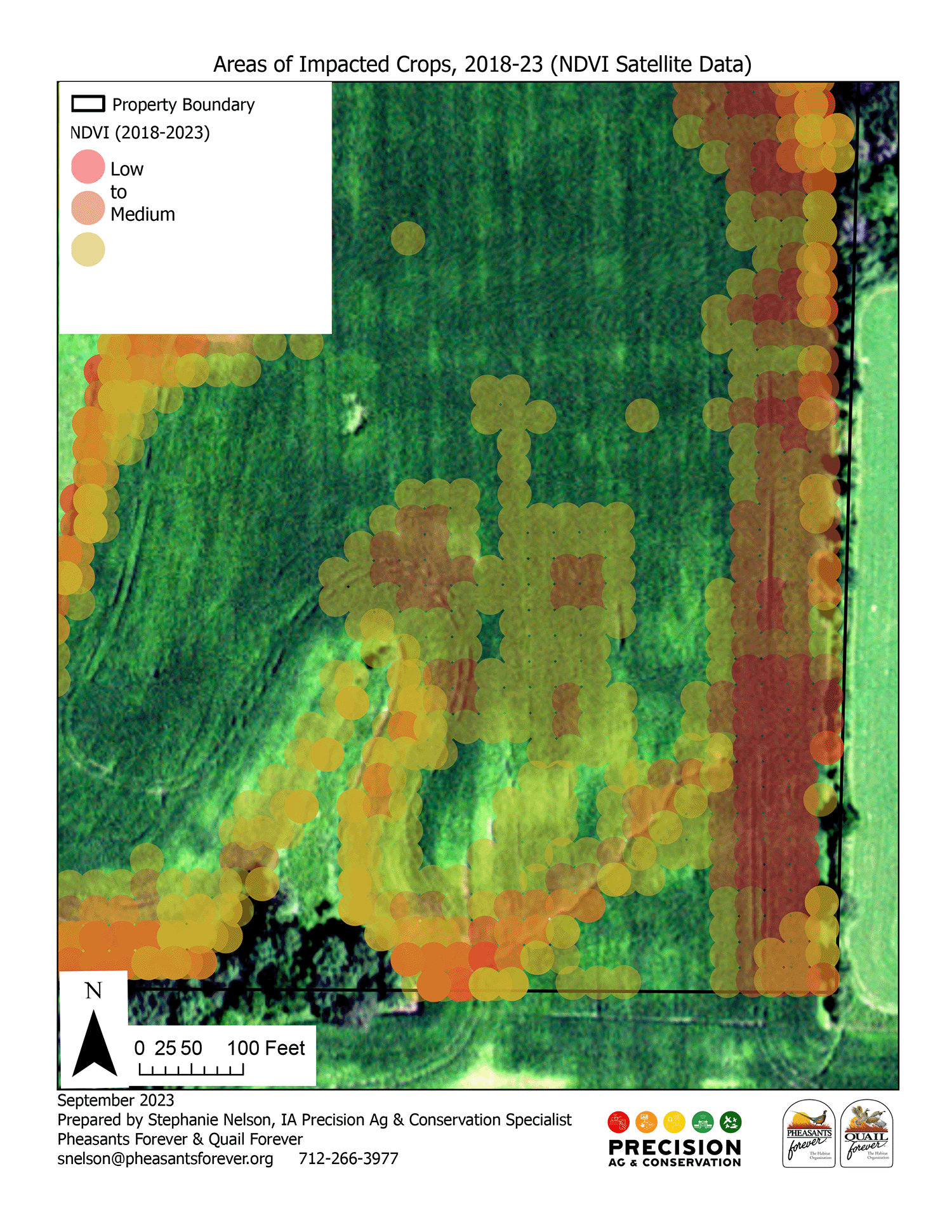
Satellite imagery of the farm shows marginal acres where crop yields and productivity are lowest. These marginal acres are a prime area to restore the natural landscape.
Using precision conservation, which is a data-driven approach for identifying marginal acres that can be converted to conservation, is an excellent way to determine which acres are least profitable and therefore, the best places to implement conservation. Technology, like satellite imagery and geographic information systems, are used to analyze the spatial data.
Precision conservation addresses specific environmental issues, such as habitat loss, soil erosion and water quality, by pinpointing areas of consistently low yields that would be more profitable in a perennial planting. Ultimately, precision conservation helps optimize resource use, ensuring that conservation actions are both scientifically sound, environmentally sustainable and economically beneficial.
Working with both PFI and Stephanie Nelson of Pheasants Forever, a plan was put in place to convert those hilly areas of the farm into critical habitat for wildlife and to act as a filter for soil runoff from the areas of the farm still in production.
Using satellite imagery, Stephanie was able to identify the areas that could be restored to habitat, practically down to the square meter, following the landowner’s goals to leave as much land in row crop as possible.
“This imagery really gave us a great insight into what the land had been doing over time and what it was doing now. We could even see things such as not getting good growth under this tree or near that edge,” the farmer said. “I took that plan back to the NRCS and FSA and once it was approved, we started getting to work.”
The final plan included 13 acres of marginal land placed into the Conservation Reserve Program as habitat where it will earn annual CRP rental payments. An additional one-time incentive payment on the acres remaining in production came from Pheasants Forever. This incentive is available to Iowa and Minnesota farmers and landowners who make a change based on the Pheasants Forever precision conservation analysis process. Additional cost-share to establish prairie strips is available through PFI’s Habitat Incentives Program and can be stacked with the CRP incentive.
The farm is bordered by wide buffer areas and timber. Areas near timber were selected for precision conservation.
Along with the 13 acres converted to CRP, half in pollinator habitat and half in prairie strips, the farmer had additional goals in mind such as creating a border around the entire field, reducing or negating erosion concerns from the land in production as well as creating a corridor from one area of the farm to another that would serve to allow wildlife to move more easily across the farm.
A farm just north of them served as an inspiration for the wildlife corridor. Whenever the farmer walks on the north side of their own farm, their neighbors’ CRP corridor is teeming with pheasants, quail and other wildlife that adds beauty as well as function to his neighbors’ farm, and the farmer wanted to emulate that on their own land.
“At the end of the day, I did precision conservation for the land to reduce erosion and improve the habitat.”